Rating Curves
Welcome to our four-part series of articles about rating curves
- Rating Curves Part 1: Webinar recording and background resources
- Rating Curves Part 2: What is a rating curve?
- Rating Curves Part 3: Extracting flow and stage results from a 2D model
- Rating Curves Part 4: Sensitivity analyses
introduction
A rating curve typically correlates water surface elevations with discharge rates. That sounds like a straight-forward process, but rating curve development is fraught with complexity and uncertainty. Water surface elevations are relatively simple to measure using high water marks, photographs, staff gauges, or stage recorders; the corresponding discharge rates, on the other hand, can prove to be much more enigmatic because flow measurements have to account for what is going on in the invisible realm below the surface of the water. In this series of articles, we’ll highlight some best practices and potential pitfalls associated with the “scientific art” of plotting and refining rating curves using measurements, equations, and/or models.
course
This website provides background resources for our Rating Curves training course, delivered in partnership with the International Water Association and Australian Water School. Click here for details and registration links. Be sure to use coupon code “hydroschool-10” to receive a 10% discount on all online courses.
Webinar
Here are some of the resources highlighted in the webinar:
- Krey Price’s AWS rating curves webinar presentation slides
- John Fenton’s AWS rating curves webinar presentation slides
- John Fenton’s papers, including many publications about rating curves
- On the generation of stream rating curves, John Fenton, Journal of Hydrology, 2018
- A computer program for stream rating curves, John Fenton, Alternative Hydraulics Paper 9, Feb 2021. (Self-executing file download)
- The Calculation of Streamflow from Measurements of Stage, by John Fenton and Robert Keller, CRC for Catchment Hydrology, Sep 2001
- Tony Ladson’s blog article on rating curves, including links to publications and resources
- Australian Rating Curves Presentation by Ray “Rainfall” Maynard from the 2016 Christchurch Rating Curves Workshop
- What does a hydrographer do? from the Australian Department of Defence’s Hydrographic Office
- How stream flow is measured, a good summary of rating curve development published by the USGS
- Guidelines for the collection of video for Large Scale Particle Velocimetry (LSPIC), USGS, 2018
- Modelling Rating Curves to Manage Uncertainty in the Fitzroy River Catchment in North West Western Australia, Lauren Greening, Leith Bowyer and Dean Pegoraro, Australian Hydrographer, July 2019
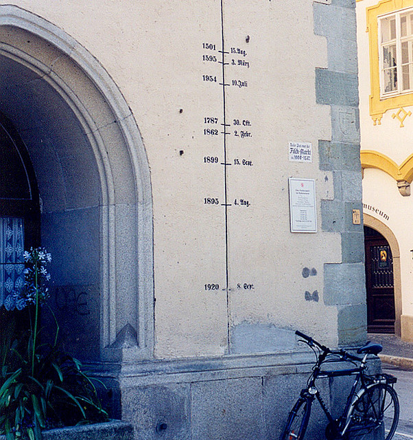
To set up some of the complexities associated with rating curves, take a look at the high water marks painted on the Rathaus in the “three-river” city of Passau, Germany in this 2002 photo:
[Photo credit: Roger Wollstadt]
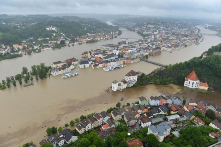
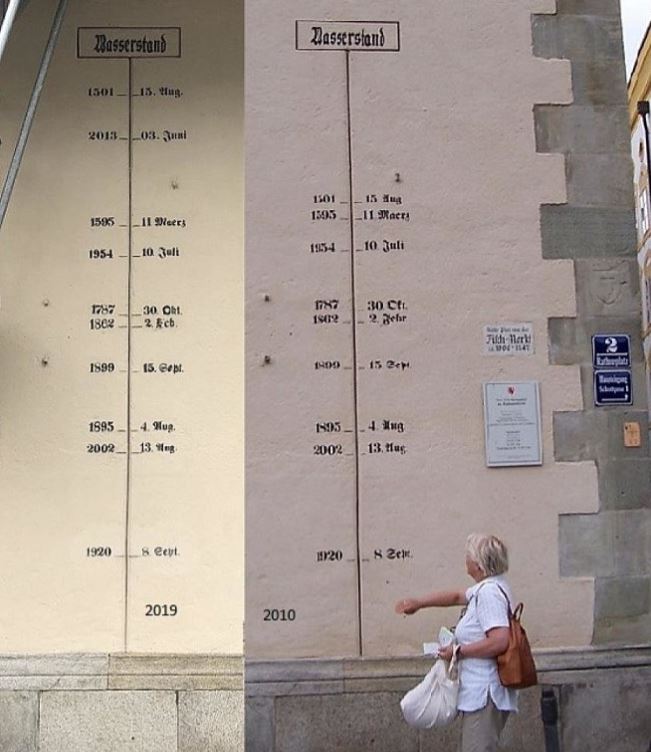
When the 2013 floods far exceeded any previously recorded historical levels, city historians went back to the records, adjusted the heights, and corrected the painted levels:
Media reports that initially called the flooding the “worst ever” began to call it the “worst in 500 years” once the 1501 high water mark was corrected. But we have to be very careful with this sort of statement. If we listed the river discharge next to the flood levels, would the flow rates likewise be in ascending order from bottom to top? If so, we might be looking at a smooth rating curve that could be representative of this location. In reality, however, the 2013 flood levels may well have resulted from far lower discharge rates than previous events, possibly exacerbated by geomorphological changes, subsequent development, or other variations in the river system. If any of the flow rates are indeed out of order, we would need to look at a family of rating curves in Passau.
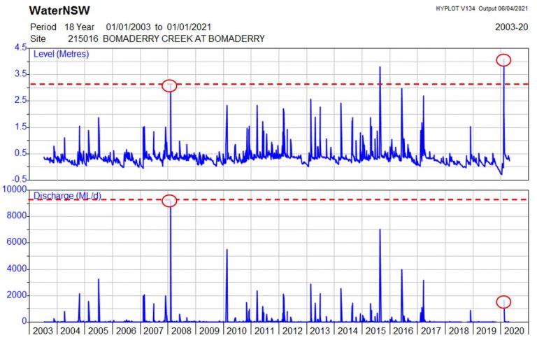
Here is an example of coincident flow and stage records that – if correct – indicate a change in the adopted rating curve over time. The highest stage ever recorded (in 2020) was accompanied by a fairly minor flow event, while the highest flow ever recorded (in 2008) was accompanied by a stage level that has been exceeded several times since. Whether it is due to tidal action, wind forces, confluence areas, debris blockage, or other factors, there are certainly valid cases where relationships between flow and stage change over time. Could this have happened in Passau?
So how would you go about determining historical discharge rates in order to assess which flood event in Passau truly was the worst in terms of total discharge? Because we can’t retroactively measure flow, we would need to create hydraulic models that result in each of the recorded flood levels. For the model results to be meaningful, however, each event would need its own geometric data, complete with an accurate historical survey or terrain file reflecting the bathymetry of the river channel at the time along with floodplain development, vegetation, and other time-varying factors that can affect the hydraulic roughness.
[And if we take it back even further to the chain of precipitation events across three different basins that came together to generate these floods in Passau, the spatial and temporal distribution of the rainfall and catchment characteristics will have a tremendous impact on the resulting runoff; the precipitation depths that resulted in these floods could likewise vary across the board, showing no apparent correlation to the order of events painted on the old Rathaus!]
In short, the idea of simply turning stage into discharge by means of a single, smooth curve sounds very appealing, but there is a lot more to the process!
Read the rest of our four-part series of articles on rating curves here, including how to extract rating curves from HEC-RAS and other models:
- Rating Curves Part 1: Webinar recording and background resources
- Rating Curves Part 2: What is a rating curve?
- Rating Curves Part 3: Extracting flow and stage results from a 2D model
- Rating Curves Part 4: Sensitivity analyses


